The Hyderabad Regional Ring Road (RRR) is a massive infrastructure project underway in Telangana, India. This ambitious plan aims to create a 340-kilometer 6-lane expressway circling the city of Hyderabad. The RRR plan is strengthening the existing road network, making it one of the major projects in Hyderabad. This RRR plan covers 13+ major cities of Telangana.
What is RRR (Regional Ring Road)
| Name | Hyderabad Regional Ring Road (HRRR) |
| Length | 340+ |
| Phases | Northern=160+ Southern=180+ |
| Lanes | 6 |
| Districts Covers | Ranga Reddy. Bhuvanagiri (Yadadri- Bhuvanagiri) Siddipet Medak Sangareddy |
| Total Cities Covered | 12+ Cities |
The Hyderabad Regional Ring Road (RRR) is designed to be a modern expressway. This road will strengthen the existing Outer Ring Road and cover more than 13 cities. Unlike regular roads, it will have limited entry and exit points, allowing for faster and safer travel. Think of it as a high-speed loop around Hyderabad, efficiently connecting various districts and towns.
This total RRR project costs more than ₹16,000 crore, with the central and state governments sharing the cost equally (50% each).
Key Points of RRR
- Length and Lanes: The RRR is a planned 6-lane expressway with a total length of 340 kilometers.
- Purpose: It aims to bypass Hyderabad city, functioning as an alternative route for long-distance traffic and reducing congestion within the city. This will improve travel times and connectivity between districts around Hyderabad.
- Cost: The project is estimated to cost around Rs. 26,000 crores.
- Connectivity: The RRR will connect various important national highways including NH-44, NH-164, NH-65, NH-765, NH-63, SH-1, and SH-19.
- Phases: The construction is planned in two phases – northern and southern halves.
- Interchanges: There will be 8+ new interchanges connecting the RRR to the existing Outer Ring Road (ORR).
Why is the RRR being built?
- Strengthening Connectivity: Hyderabad’s existing road network, including the Outer Ring Road (ORR), is nearing capacity. The RRR will provide much-needed relief by decongesting existing roads and offering alternative routes for long-distance travel.
- Boosting Regional Development: The RRR’s path will connect several towns and districts surrounding Hyderabad. This improved connectivity is expected to spur economic growth in these areas by attracting businesses and industries.
- Linking Major Highways: The RRR will act as a crucial link between various national highways (NH) and state highways (SH) passing through the region, including NH 44, NH 65, and NH 163. This will improve movement of goods and people across the state.
Hyderabad RRR Master Plan Structure Complete Details
We know the RRR has a total length of over 340 km and covers more than 12 major cities near Hyderabad.
The RRR master plan is divided into two phases: Northern Phase and Southern Phase.
| Key Point | Northern Phase | Southern Phase |
|---|---|---|
| Length (km) | 160 | 182 |
| Cities Covered | 7 cities | 6 cities |
| Estimated Cost (crores) | ₹10000+ Cr | ₹12000+ Cr |
| Land Acquisition (acres) | 4000 acres | Not Available |
| Status | Approved by NHAI, Surveys & Land Acquisition ongoing | Works Started |
Northern Phase:
The northern part of the RRR covers more than 160 kilometers and includes over 7 cities. The total cost of the northern part is estimated to be over Rs. 10,000 crores.
Cities covered in the northern part:
- Sangareddy Junction
- Daulatabad
- Narsapur Junction
- Shivampet
- Toopran Junction
- Nachaaram
- Gajwel Junction
- Jagdevpur
- M. Turkapally
- Bhuvanagiri
- Valigonda
- Sangem
- Choutuppal
Status of RRR Northern Part:
The National Highways Authority of India (NHAI) has approved the northern part and begun surveys. Land acquisition has commenced, requiring over 4,000 acres.
District-level personnel have started working on land acquisition. The central and state governments will share the total cost equally (50-50%).
Southern Phase:
The southern part of the RRR is longer than the northern part, with a total length of over 182 kilometers. It covers more than 6+ cities.
Cities covered in the southern part:
- Choutuppal
- Ibrahimpatnam
- Kandukur
- Amangal
- Chevella
- Shankarpally
- Sangareddy (loop back)
Hyderabad GHMC Zones & Circles Full Details
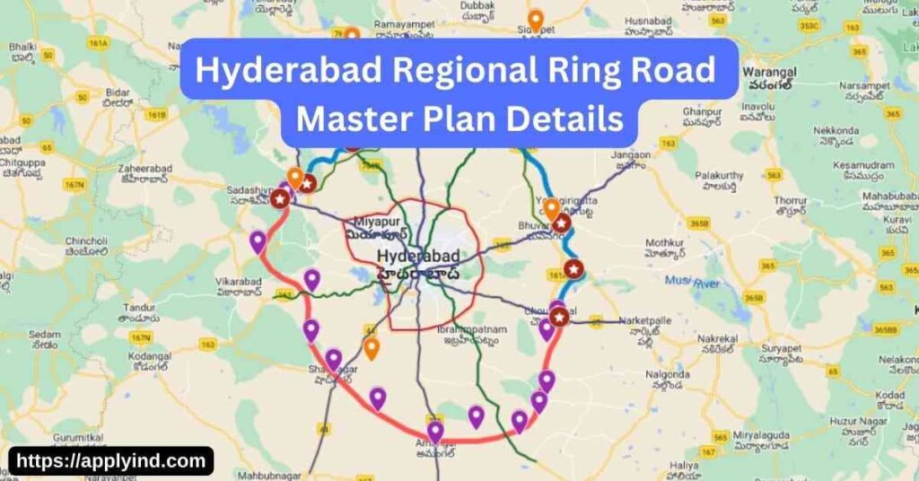
Hyderabad Regional Ring Road Map & Route
Hyd RRR covers more than 12+ cities and 5 districts.
Northern part covers 8 cities and Southern part covers 7 cities.
They are:
| Northern part (158 kms) | Southern part (182 kms) |
|---|---|
| Sangareddy | Choutuppal |
| Narsapur | Ibrahimpatnam |
| Toopran | Kandukur |
| Gajwel | Amangal |
| Yadadri | Chevella |
| Pragnapur | Shankarpally |
| Bhongir | Sangareddy |
| Choutuppal |
Villages & Mandals Covered in Hyd Regional Ring Road
| Sangareddy | Medak | Siddipet | YADADRI-BHUVANAGIRI |
|---|---|---|---|
| KONDAPUR MANDAL: Malkapur Girmapur | NARSAPUR MANDAL: Nagulapalle Moosapeta Mohammadabad Pedda Chinthakunta Rusthum peta Seetharampur Malparthi Achapet Reddipalle Chinna Chinthakunta Kazipeta Manthur Gollapalle Tirmalapur Tuljapur | RAIPOLE MANDAL: Begumpet Yalkal | CHOUTUPPAL MANDAL: Nelapatla Chinna Kondur Talla Singaram Swamula vari lingotam Choutuppal Lingojiguda Panthangi Tangedu Palli |
| SADASIVPET MANDAL: Peddapur | KOWDIPALLE MANDAL: Venkatapur | JAGDEVPUR MANDAL: Alirajpet Itikyala Peerlapalle | VALIGONDA MANDAL: Pahilwan Pur Kanchanapalli Tekula Somaram Redlarepaka Proddutur Varkutpalle Gokaram Valigonda |
| SANGAREDDY MANDAL: Nagapur Irigipalle Chintalpalli Kalabgur Sangareddy Tadlapalle Kulabgur | SHIVAMPET MANDAL: Lingoji guda Kothapeta Ratnapur Pambanda Usirikapalle Pothula Boguda Gundlapalle Konthanpalli | MARKUK MANDAL: Markuk Pamulaparthi Angadi Kistapur Chebarthi Erravalli | BHUVANAGIRI MANDAL: Bhuvanagiri Rayagiri Kesaram Penchikala pahad Tukkapur Chandupatla Gouse nagar Erramballi Nandanam |
| HATNURA MANDAL: Kasala Devulapalli Hatnura Doulatabad | TOOPRAN MANDAL: Vattur Dandupalle Nagulapalle Toopran Islampur Datarapalle Gundreddy palle Kistapur Venkatayapalle Narsampalle Malkapur | WARGAL MANDAL: Majeedpalle Mentoor Jabbapur Mailaram Konday palle | YADAGIRIGUTTA MANDAL: Mallapur Datarpally |
| CHOUTKUR MANDAL: Shivampet Vendikole Venkata kistapur Lingampalle Korpol | MASAIPETA MANDAL: Masaipet | GAJWEL MANDAL: Bangla Venkatapur Makta Masan palle Komati Banda Gajwel Sangapur Mutrajpalle Pragnapur Sirigiri Palle | TURKAPALLY MANDAL: Gandamalla Veerareddy palle Konapur Ibrahimpur Dattayi pally Velpu pally |
InterChanges of Regional Ring Road with Outer Ring Road
The HRRR will have special spots to connect with other major roads. These are called interchanges, and there will be 8 of them on the northern part of the highway.
Here are some of the locations where these interchanges will be built:
- Mumbai Highway: Between Peddapur and Girmapur villages
- Sangareddy-Nanded Road: Near Shivampet (Fasalwadi)
- Medak Road: Between Reddypalli and Chinthakunta
- Karimnagar Highway (Rajiv Highway): Near Gouraram (Gundanpally)
- Nagpur Highway: Near Toopran (Masaipet)
- Vijayawada Highway: Near Choutuppal (Bangarigadda)
- Jagdevpur-Choutuppal Road: Between Mandapuram and Penumativanigudem
- Warangal Highway: Bhuvanagiri
National HighWays Connected Hyd RRR
National Highways (NH):
- NH 44 (North to Srinagar, South to Bangalore)
- NH 65 (West to Mumbai, East to Vijayawada)
- NH 161 (North to Nanded and Akola)
- NH 163 (West to Nagpur and Bhopalpatnam)
- NH 765 (South to Warangal and Srisailam)
Additional Connections:
- State Highways (SH) – Improves travel within Telangana and nearby regions.
- Connects around 20 towns and 300 districts.
What’s the current status of the RRR?
The RRR is a large-scale project divided into two sections: northern and southern. The National Highways Authority of India (NHAI) is overseeing the construction under the Bharatmala Pariyojana initiative. As of March 2024, the project is still in the initial stages. A major hurdle is land acquisition, with the Telangana government expediting the process to meet its completion deadlines.
The Hyderabad Regional Ring Road is a great visionary project started for Telangana. While it experiences some challenges, it is steadily improving construction works. Mainly, the RRR boosts economic growth and creates a more efficient transportation network for Hyderabad and Telangana. We hope it completes as soon as possible.